High-Definition Network Map
Kolkata Metro Network Route Map 2026 — Interactive Corridor Schematics
Official operational corridors of Kolkata Metro Network including Blue Line, Green Line, Purple Line, Orange Line with interchange station connections.
Official Kolkata Metro Network Network Map
Schematic network diagram covering operational corridors and interchanges in Kolkata.
100%
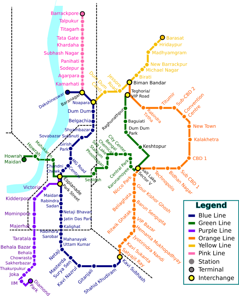
Lines:Blue Line (Line 1)Green Line (Line 2)Purple Line (Line 3)Orange Line (Line 6)
Drag to pan•Source: Metro Railway, Kolkata
Line Legend
Blue Line(Line 1)
Green Line(Line 2)
Purple Line(Line 3)
Orange Line(Line 6)
Interchange Station (Noapara, Esplanade)Standard Metro StationUnderwater River Crossing
Complete Line & Station Sequence
Blue Line(Line 1)
26 stations- 1. Dakshineswar
- 2. Baranagar
- 3. NoaparaInterchange
- 4. Dum Dum
- 5. Belgachia
- 6. Shyambazar
- 7. Shobhabazar Sutanuti
- 8. Girish Park
- 9. Mahatma Gandhi Road
- 10. Central
- 11. Chandni Chowk
- 12. EsplanadeInterchange
- 13. Park Street
- 14. Maidan
- 15. Rabindra Sadan
- 16. Netaji Bhavan
- 17. Jatin Das Park
- 18. Kalighat
- 19. Rabindra Sarobar
- 20. Mahanayak Uttam Kumar
- 21. Netaji
- 22. Masterda Surya Sen
- 23. Gitanjali
- 24. Kavi Nazrul
- 25. Shahid Khudiram
- 26. Kavi Subhash (New Garia)Interchange
Green Line(Line 2)
12 stationsPurple Line(Line 3)
7 stationsOrange Line(Line 6)
5 stationsVerified Kolkata Metro Network Network Schematics
Map schematic reflects active operational corridors as published by Metro Railway, Kolkata (Ministry of Railways) and Ministry of Railways / Urban Affairs, Government of India.
Verified for 2026 OperationsReport Map Update